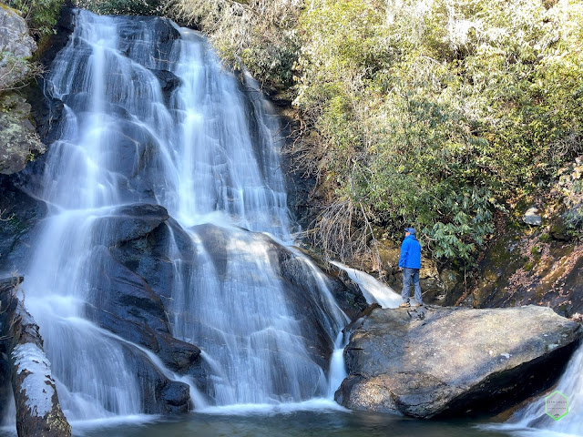
Coyote Falls, Cashiers, North Carolina
Once and a while you come across a hidden gem in almost plain sight. This is the case with the rarely visited Coyote Falls. Located only a 1/4 down Hwy 107 from the very popular Silver Run Falls turnoff, Coyote Falls remains seldomly traveled.
I was making plans for a weekend of hiking one evening, and speaking to my friend and fellow explorer Leslie about some Cashiers/Glenville area hikes when she mentioned Coyote Falls. I had never heard of this falls, so of course, like any other person these days in the age of technology, I googled it. There was NOT much information available online, but I was able to find GPS coordinates for the trailhead, which is really all I needed. There were a few photos, but nothing on AllTrails and a little on google.
The turnoff of the GPS coordinates lead me to the side of Hwy 107 and it was unoccupied and looked inviting. I parked the car, got Gus together, and headed down the visible deer trail along the creek. Someone who hung up some bright orange ribbons along the way to help visitors stay on the trail. Recent storms had knocked down several large branched and trees making some parts of the trail hard to follow clearly. I don't think I would classify this trail as a "bushwhack", but you just need to use common sense and a keen eye to maintain your course parallel to the creek.
As you approach Coyote Falls, the audible sounds start to thunder throughout the landscape. After a small stream jump, you can start to see the falls through the brush. I visited in winter, but I can imagine in summer with full foliage you might not be able to see them as quickly.
Once you move through the final turn in the trail, there she is in all her glory... Coyote Falls! This is a medium-sized waterfall with one main cascade flowing quickly down the middle. There are a few large rocks at the base to stand on and admire, along with a large rock on the right-hand side of the falls.
I took out the camera and drone and started to cover the falls and try to do a bit of justice with video. Due to the large canopy above and around the falls, flying the drone was a bit precarious and I had to exercise caution for the aerial shots. I was able to scramble across the rock wall and made it to the large boulder on the right side of the falls for a few photos. The camera remote controller paid for itself again!
After packing up when completed, Gus and I headed back to the car on our quick hike back out.
As I indulge myself more and more in some of the less popular locations after visiting most of the main attractions already, I have become part of several "waterfall groups" online. I also received numerous comments on my videos condemning my coverage of photos or videos of the "hidden gems". I don't understand this mentality. Why should these glorious natural wonders be hidden and only allowed for a select few? If these falls aren't visited, shared, and passed down, then they will slowly become unknown and forgotten like many other great waterfalls in the area. My personal belief is that if you are able-bodied enough and willing to physically make the trip, then you should at least be given the chance to decided to try and visit these lesser-traveled locations. Waterfalls and hiking should be for anyone willing to put in the effort. That's at least my humble opinion.
Quick Videos of Our Hike:


Simply gorgeous- thanks for sharing!! I don't venture out as much as I would like as I am alone
ReplyDeleteThanks for stopping by and taking the time to go through it!
Delete