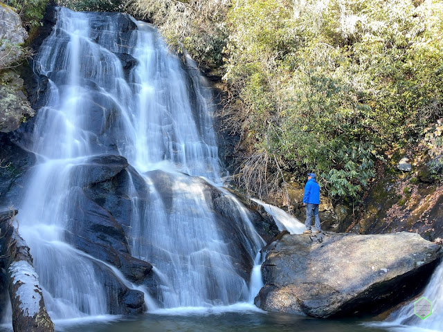
Crane Creek Falls & Yellow Jacket Falls, South Carolina
We had been planning this trip for weeks, but I was looking forward to it even longer. I had seen several photos for both Crane Creek Falls & Yellow Jacket Falls a handful of times, but never any real video, and all the photos were a bit tough to tell the scale of the falls.
Our little group consisting of Leslie, Lindsay, Josh, David, and myself were met early on a Saturday morning with a HUGE cloud inversion in the Cheoee Valley. This created a dense fog as we moved up the mountain on the dirt road to the GPS coordinates for the beginning of the hike. As we parked the cars, the fog engulfed us and the tops of trees were not even visible but looked merely like shadows in a dimly lit vast forest. We gathered our gear and proceeded towards the direction of the falls on the GPS.
Please keep in mind, this was no ordinary hike. There were no trails, markers, blazes, beaten down deer trails, or dirt. We were hiking on top of the natural forest, ducking under branches, the rhododendrons reached out to scratch us as if to say "not so fast". Our hike was now a bushwhack. We were quickly searching for the easiest and safest ways to scramble across the steep slopes of the thick underbrush and slippery wet leaves. There was more than once where several of us debated the best route to our destination.
As we made our way out of the first small creek crossing, the mud made itself known. It was a difficult task to claw our route to the top of the next hill where it flattened out a bit. Then we could hear her; Crane Creek Falls wasn't far off now. We all picked up the pace a bit out of joy and found our inspiration. The thunderous roar of this +40 ft waterfall was booming with excitement. We caught several glimpses of the falls as we headed down the final slope to her base creek. Shoes soaked, skin scratched and eyes wide, we laid gaze upon this rarely visited falls. All of us were smiling ear to ear.
Crane Creek Falls is a large sheer drop syle falls. The water cascades vertically with long fall sections. I had seen a few photos in my research, but they all appeared similar to each other. I wanted to be able to capture the magnitude and scale of the gorgeous waterfall. We all took several pictures and videos, then it was time for the drones to do their work too. Josh flew his first, while I waited to fly second. There was not much room in the canopy for error with flying and the fog was still very dense, so we took our time, flew slow, and deliberately to avoid collision with trees.
Afterward, we said our goodbyes to the falls and proceed up the opposing embankment to make our way up and over to Yellow Jacket Falls. David and Leslie had utilized a rope to assist everyone with the steep, muddy, and slippery ascent. Thank goodness too, because Gus (my Boxer) needed a bit of help maneuvering around a series of exposed roots.
Once on top of the ridge, it was a pretty easy shuffle over to Yellow Jacket Falls. You can hear and see them almost immediately after passing Crane Creek Falls audibly. The booming thunder of Crane Creek Falls gave way to the rushing whitewater sound of Yellow Jacket Falls. We made our way down the embankment utilizing some downed trees as guides. These fallen giants helped keep the rhododendrons at bay.
We again took several photos and videos, flew our drones to try and do the falls justice, then packed up for the trip back to the cars.
Once again, utilizing the rope, we made our way up the thickest embankment yet covered in sharp rhodos, then at the top of the hill, determined the best way back to the vehicles. There is something to say about returning routes of hikes. They seem to go so much quicker than hikes into the destinations. We crossed over the small creek and ravine then we were back at the cars before we knew it! It was only a 1.3 mile RT, but it was a tough 1.3 basically on your hands and knees the majority of the time.
If you decide to attempt this scramble or any other type of bushwhacking, please know your limits. I would only recommend strong hikers, good map readers, and able-bodied people to attempt such a sojourn. It is not for the faint of heart or the meek. You will get scratched by trees, you will get muddy and dirty, you will be rewarded with sights that have been lost to the ages of time and only visited seldomly. There is a risk, but also a reward.
Until the next one...
Distance: 1.35 miles
Vertical: 381 ft
Quick Videos of Our Hike:


Comments
Post a Comment